Wildfire Smoke over the Sea of Okhotsk
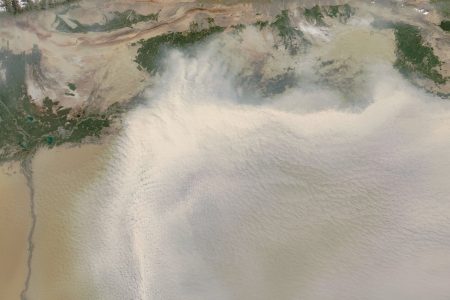
Wildfire Smoke over the Sea of Okhotsk Smoke from wildfires streamed across the Sea of Okhotsk in late July 2011. The Moderate Resolution Imaging Spectroradiometer (MODIS) on NASA’s Aqua satellite captured this natural-color image on July 27, 2011.
Nearly 120 fires were burning in the Russian Federation as of July 28, 2011, according to EMERCOM of Russia. Nineteen of those blazes were in the Far Eastern Federal District.
Marked by tiny red dots, some actively burning fires appear just west of Sakhalin in this image, and those fires produce heavy smoke. The thick river of smoke that blows over the Sea of Okhotsk, however, appears to have originated farther west.
An expanded version of this image is available through the MODIS Rapid Response System. The Sea of Okhotsk is a marginal sea of the western Pacific Ocean. It is located between Russia’s Kamchatka Peninsula on the east, the Kuril Islands on the southeast, Japan’s island of Hokkaido on the south, the island of Sakhalin along the west, and a stretch of eastern Siberian coast along the west and north. The northeast corner is the Shelikhov Gulf. The sea is named after Okhotsk, the first Russian settlement in the Far East.
Credit: NASA image courtesy the MODIS Rapid Response Team at NASA GSFC. Caption by Michon Scott.
News coming your way


