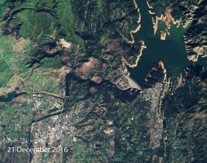
Satellite images show drastic water level rise at Oroville Dam
Today’s Images of the Day come from NASA’s Copernicus Sentinel-2A satellite and highlights the drastic rise of the water levels at the Oroville Dam in northern California.
The two images, taken from the same position on December 21st, 2016 and January 30th, 2017, illustrate just how quickly the height of the dam water rose in just a few short weeks. In the first image, far more shoreline is visible, and several islands can be spotted to the north of the dam. After the rains, however, those same islands are almost entirely underwater.
The water color is also much darker in the January image, likely due to sediment and debris that washed into the dam with the rainwater.
The spillway looks to be dry in the first image, but by the end of the January, it appears to be gushing with water. Sources at the dam say this is the first time water has ever entered the spillway. The excessive amount of water pouring through the spillway caused a jagged crater to develop in its lower section. This caused serious safety concerns and led to the evacuation of over 200,000 people in the area.
The Oroville Dam is located about 65 miles north of Sacramento and is the second-largest reservoir in the country. Measuring it at 235 meters, it is also the tallest dam in the United States.
—
By: Rory Arnold, Earth.com Staff Writer


