Tornado and Severe Thunderstorms Strike Oklahoma

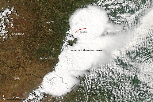
Tornado and Severe Thunderstorms Strike Oklahoma. On May 20, 2013, a supercell thunderstorm in central Oklahoma spawned a destructive tornado that passed just south of Oklahoma City. The Moderate Resolution Imaging Spectroradiometer (MODIS) on NASA’s Aqua satellite acquired this natural-color image of the storm system at 2:40 p.m. Central Daylight Time (19:40 Universal Time), just minutes before the devastating twister began.
The red line on the image depicts the tornado’s track. It touched down west of Newcastle at 2:56 p.m. and moved northeast toward Moore, where it caused dozens of deaths, hundreds of injuries, and widespread destruction to property and public buildings. The tornado had dissipated by 3:36 p.m., after traveling approximately 17 to 20 miles (27 to 32 kilometers).
According to National Weather Service and media reports, the mile-wide tornado had a preliminary damage rating of EF-4, with winds reaching 190 miles per hour. It had a relatively slow forward speed for such a violent storm—about 20–25 miles per hour—likely exacerbating the damage. Debris from the tornado fell as far as 100 miles (160 kilometers) away, reaching the city of Tulsa.
Below is time-lapse video of the storm system as viewed by the National Oceanic and Atmospheric Administration’s GOES-East satellite. Images were acquired every 15 minutes from 10:45 a.m. through 6:45 p.m. Central Daylight Time on May 20. You can also click here to download a quicktime version of the video. Jeff Masters of Weather Underground has also posted several ground-based videos here. And meteorologists in NASA’s Short-term Prediction Research and Transition Center posted several experimental views of the storm-damaged area at night. Tornado and Severe Thunderstorms Strike Oklahoma.
Credit: NASA image courtesy Jeff Schmaltz, LANCE/EOSDIS MODIS Rapid Response Team at NASA GSFC. NASA Earth Observatory animation by Robert Simmon, using images from GOES Project Science. Caption by Mike Carlowicz and Adam Voiland.
News coming your way


