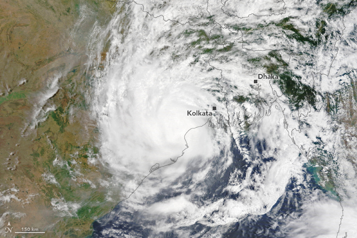
Cyclone Yaas flooded hundreds of villages in Bangladesh

Cyclone Yaas flooded hundreds of villages in Bangladesh Today’s Image of the Day from NASA Earth Observatory features Cyclone Yaas, which hit the northeast region of India in the Bay of Bengal.
The India Meteorological Department reports that Cyclone Yaas made landfall on the north Odisha coast near Balasore at 10:30 local time on May 26, 2021. The storm had sustained winds of 75 miles per hour, the equivalent of a category 1 hurricane.
According to NASA, Yaas coincided with a perigean spring tide – an especially high tide caused by the Moon and Sun being slightly closer to Earth than usual. North America is a continent entirely within the Northern Hemisphere and almost all within the Western Hemisphere. It can also be described as the northern subcontinent of the Americas. It is bordered to the north by the Arctic Ocean, to the east by the Atlantic Ocean, to the southeast by South America and the Caribbean Sea, and to the west and south by the Pacific Ocean. Because it is on the North American Tectonic Plate, Greenland is included as part of North America geographically. North America covers an area of about 24,709,000 square kilometers (9,540,000 square miles), about 16.5% of the Earth’s land area and about 4.8% of its total surface
The storm flooded hundreds of villages in Bangladesh, as well as tens of thousands of mud houses in West Bengal.
The image was captured by the Moderate Resolution Imaging Spectroradiometer (MODIS) on NASA’s Terra satellite.
Image Credit: NASA Earth Observatory
–—
By Chrissy Sexton, Earth.com Staff Writer
News coming your way


