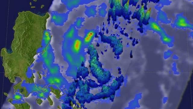
NASA satellites provided a look at Typhoon Nida
The fifth named tropical cyclone, Nida, known as Carina in the Philippines, formed in the Pacific Ocean east of the Philippines on July 29, 2016 (UTC). After moving over Luzon in the northern part of the country, Nida emerged in the South China Sea where it re-strengthened as moved toward southeastern China.NASA satellites provided a look at Typhoon Nida
The Global Precipitation Measurement mission, or GPM, core observatory satellite viewed Tropical Storm Nida on Saturday, July 30, 2016, at 11:01 a.m. EDT (3:01 p.m. UTC) when winds were estimated at 63 mph (55 knots). GPM showed an organized tropical cyclone with scattered rain bands circulating around the center of circulation west of central Luzon. GPM found that rain was falling at a rate of over 3.5 inches (89 mm) per hour in some intense feeder (thunderstorm) bands.
At NASA’s Goddard Space Flight Center in Greenbelt, Maryland, GPM data was used to create a 3-D image of the storm. Tropical Storm Nida’s rainfall structure was measured by GPM’s radar (DPR Ku Band). DPR showed that storm tops reached heights of over 10.5 miles (17 km) in intense storms within a feeder band north of Nida’s center.
GPM is a joint mission between NASA and the Japanese space agency JAXA.
[ooyala code=”ZkNHcyNTE6lPVqiMkd1QVsHbSd8TWjAO” player_id=”ce75157bc770441eaf5e849ae4d1d21f”]
On Aug. 1 at 1:15 a.m. EDT (5:15 a.m. UTC ) the Visible Infrared Imaging Radiometer Suite (VIIRS) instrument aboard NASA-NOAA’s Suomi NPP satellite captured a visible light image of Typhoon Nida approaching Hong Kong. The VIIRS image showed that Nida maintained an eye with bands of thunderstorms circling it. At the time of the image, the northwestern quadrant of the typhoon was over coastal southeastern China.
On Monday, Aug. 1, 2016, at 11 a.m. EDT (3 p.m. UTC) the Joint Typhoon Warning Center (JTWC) reported that maximum sustained winds were near 80.5 mph (70 knots/129.6 kph), making it a category 1 hurricane on the Saffir-Simpson Wind Scale. Nida was located near 21.4 degrees north latitude and 116.6 degrees east longitude. That puts the center of Nida about 187 nautical miles east-southeast of Hong Kong. Nida was tracking to the northwest at 20.7 mph (18 knots/33.3 kph).
The Hong Kong Observatory posted the No. 8 storm signal. No. 8 signal means storm force winds at sea level are expected at sustained speeds of 40 to 73 mph (63 to 117 kph), and gusts that may exceed 112 mph (180 kph). As Nida closed in on Hong Kong, two airlines, Cathay Pacific and Dragonair suspend all departures and arrivals.
The bulletin from the Hong Kong Observatory (HKO) issued at 9:45 p.m. local Time (9:45 a.m. EDT /145 p.m. UTC) on Aug. 1 noted, “Squalls, heavy rain and rough seas will progressively affect Hong Kong. Storm surge brought by Nida may cause flooding or sea water intrusion in some low-lying areas tomorrow morning.” For updated warnings from the HKO, visit: http://www.


