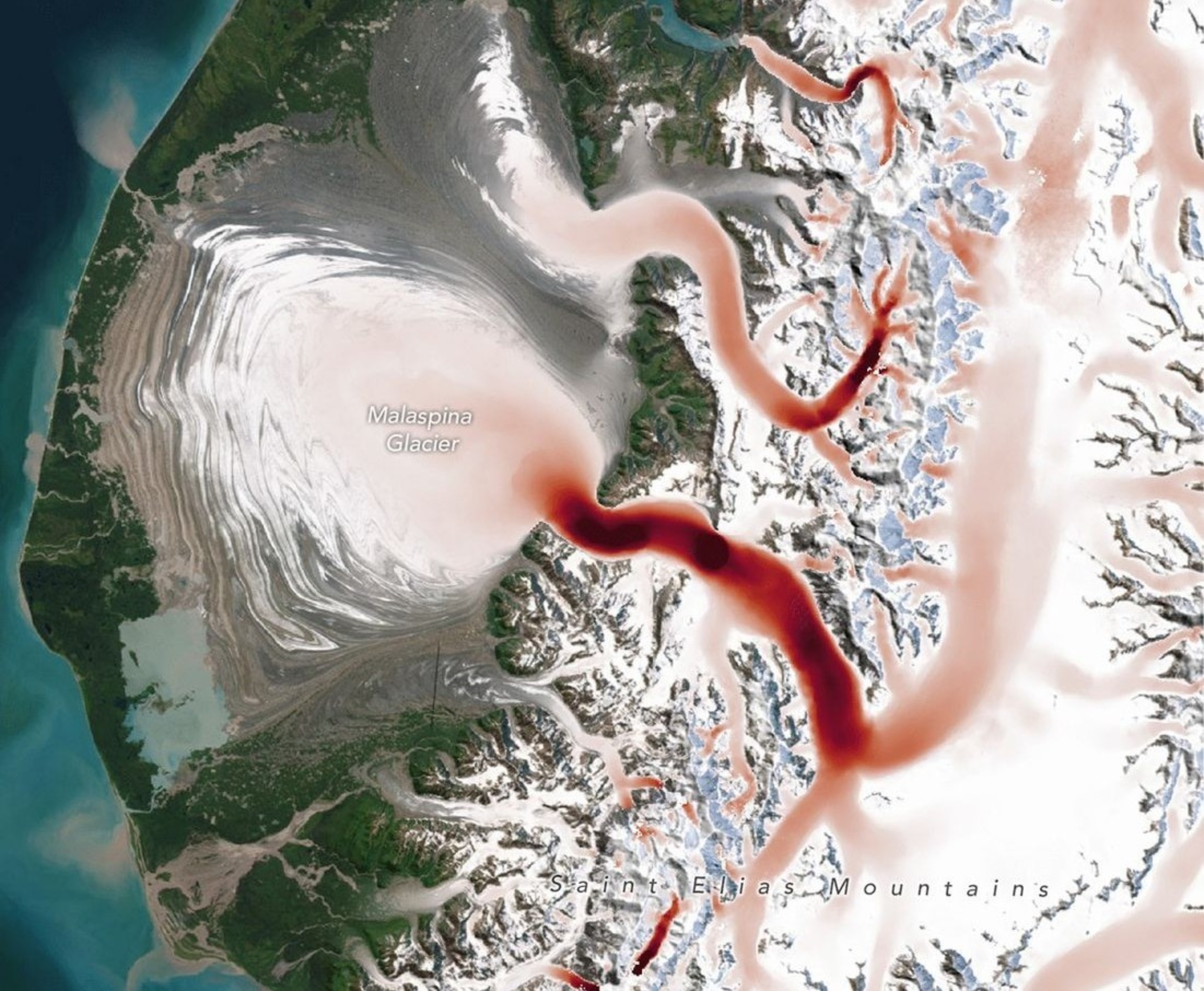
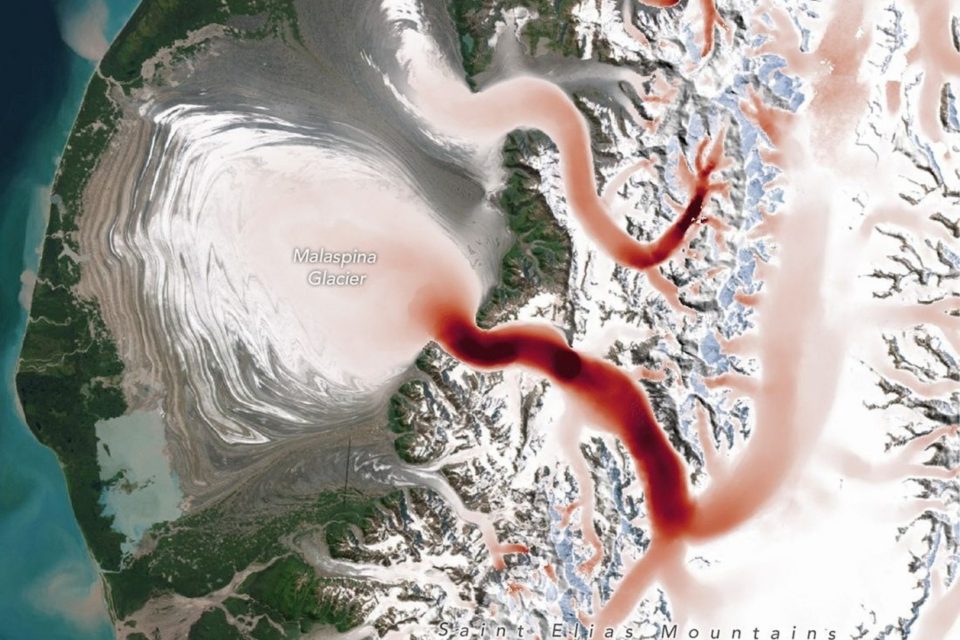


Today’s Image of the Day from NASA Earth Observatory captures Malaspina Glacier, a massive river of ice in southeastern Alaska that stretches from the Saint Elias Mountains onto the coastal plain.
At first glance, the glacier seems frozen in place. But beneath this serene surface, the ice is constantly in motion, speeding up and slowing down with the changing seasons.
A new global study shows that glaciers worldwide behave in surprisingly diverse ways, revealing important clues about how these icy giants respond to warming temperatures.
Glaciers as living rivers of ice
Glaciers are not static monuments of ice; they behave more like slow-moving rivers.
Seasonal patterns of acceleration and deceleration have long been observed in individual glaciers, but until recently, no one had mapped these movements on a global scale.
Using millions of satellite images collected from 2014 to 2022, NASA scientists have now captured the pulse of glaciers around the world, revealing patterns that are both familiar and unexpected.
The research, conducted by Chad Greene and Alex Gardner at NASA’s Jet Propulsion Laboratory (JPL), provides a comprehensive view of how glaciers respond to seasonal warming.
By tracking the movement of deep cracks called crevasses and other surface markers, the team was able to measure glacier speed with remarkable precision.
These surface features act as unique fingerprints, allowing scientists to follow the motion of ice across the globe using an algorithm developed as part of the ITS_LIVE project.
Measuring ice motion from space
The method is as elegant as it is effective. By comparing sequences of optical and radar satellite images, scientists can detect subtle shifts in glacier flow.
Crevasses and debris patterns provide reference points, enabling researchers to map variations in speed down to individual glaciers.
“Earth has over 200,000 glaciers, and we’re watching all of them closely,” said Gardner. “It’s no surprise that with this much data, a pattern started to emerge.”
The timing of these seasonal surges is closely tied to the melt season and processes at the glacier’s base.
“Glaciers are like rivers of ice that flow down mountains toward the sea. When warm air melts the upper surface of a glacier, all that meltwater can make its way down to the base of the ice and act like a lubricant, causing the glacier to speed up,” said Greene.
This meltwater forms small conduits at the base, increasing pressure and reducing friction, which allows the ice to slide more easily over the uneven ground beneath it.
Seasonal rhythms across the globe
The research revealed distinct regional differences in how glaciers respond to seasonal warming. In Alaska, glaciers tend to reach their peak speed in spring, while glaciers in Arctic Europe and Russia typically accelerate later, in summer or early fall.
The Malaspina Glacier provides a clear example: in early spring, the first meltwater begins to drain through cracks in the ice, triggering a surge in motion.
By late summer, larger channels form beneath the glacier, pressure drops, and friction increases, slowing the flow once again.
Understanding these seasonal patterns is more than a scientific curiosity. By tracking how glaciers respond to short-term temperature changes, researchers can gain insight into their longer-term health.
“We wanted to check the health of Earth’s glaciers, so we measured their pulse. Now we just need to keep an eye on their temperature,” said Greene.
The study revealed that even small increases in warming can accelerate glacier flow, and that these seasonal fluctuations are linked to longer-term glacier change.
In other words, how a glacier moves in spring and summer can serve as a vital sign of its resilience to climate change.
Global implications of the study
Mapping glacier motion globally has significant implications for understanding sea-level rise.
Glaciers that accelerate quickly in response to seasonal melting may also lose mass faster over time, contributing to rising oceans.
Conversely, glaciers that respond more slowly may be more resistant to long-term warming. The NASA analysis provides a foundation for predicting which glaciers are most vulnerable and could inform regional strategies for mitigating the impacts of climate change.
Beyond practical applications, the study highlights the complexity and variability of Earth’s frozen landscapes.
No two glaciers respond in exactly the same way, and understanding these differences is essential for painting a full picture of our planet’s changing climate.
By combining satellite observations with innovative analysis techniques, scientists are beginning to unlock the hidden rhythms of the world’s ice, offering a new way to monitor some of the most remote and dynamic regions on Earth.
Image Credit: NASA Earth Observatory
—–
Like what you read? Subscribe to our newsletter for engaging articles, exclusive content, and the latest updates.
Check us out on EarthSnap, a free app brought to you by Eric Ralls and Earth.com.
—–


